Before we resume our look at Gust’s probate records, I wanted to share some observations about where the family lived between 1882 and 1907, when Gust died.
Mom and I stopped at Bethlehem Covenant Church in June and were able to inspect the old church books. The listing for Gust’s family showed that they left the Bethlehem church and transferred to the Swedeburg church in 1900. My guess is that they lived in Rock Creek Precinct, Lancaster County up until 1900.
I have a few hints about where they may have lived:
- The Nebraska 1885 Census lists them in Lancaster County’s Rock Creek Precinct but doesn’t say where exactly they lived. Some of the names of their neighbors were Peter Asplund, Hans Hanson and Emily Buffman. Fast forward almost 20 years and a 1903 atlas for Lancaster County shows these people living in the vicinity of Sections 14 and 15 of the Rock Creek precinct. I’ve outlined Sections 14 and 15 on the map below to show this general vicinity.
-

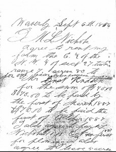
Gust Rudeen 1886 lease agreement – click to enlarge I have a handwritten agreement dated September 6, 1886 that shows Gust renting an 80-acre farm in the E½ NW¼ of Section 27 from a Mr. Nichols. That 80-acre parcel is shown in blue on the map below. I don’t know whether they just rented the ground or if they actually lived there.
- Uncle Carl Rudeen had a 160-acre farm as shown in red in Section 35.
- Carl’s two daughters married and lived in the area, too. Daughter Augusta married John August Anderson with whom she had three children. Middle child Frans August “Frank” was the one Gust had lent money to. In 1903, not too long before Gust’s death, Frank was renting a property in Section 14. There is also a J.A. Anderson property in Section 14 . This could have been cousin Augusta’s farm following the death of her first husband. I wonder if Gust Rudeen held the Frank Anderson property before he loaned Frank the money to rent it himself?
- Carl’s other daughter Amanda Christina married John Holmquist. They appear to be living in Section 35 near Uncle Carl.
This is an interactive map, you can zoom in and out select a photo background instead of the map, if that helps you get your bearings (click on the arrow to the right of the “Base Map” label in the legend box).
The church books show that they left Bethlehem Covenant in 1900, and the family shows up in the 1900 Census for the Saunders County Rock Creek Precinct (so confusing!!!).
The 1907 atlas lists the family as renters in Section 24. One of the landowners in this section was none other than Nilla Martinson, most likely the widow of my great-great-great-grandfather John Martinson. Of course Gust’s son Lawrence (my grandfather) would eventually marry Nilla’s grand-daughter Clarinda (my grandmother). John Martinson died in 1901 but Nilla lived until 1917. It’s very possible that she held land in her own name in 1907. I don’t know for sure that the Rudeen family rented the Martinson farm, but it just can’t be coincidence, can it?
Section 24 is about three miles west and two miles north of Ceresco. Neighbors on the 1907 map were Rawlings, Dahlstrom, Harrell, Dooley and a plethora of other Swede and Czech names. When we visited Grace Lutheran Church in June, my dad noticed that there were a lot names in the Lutheran confirmation classes from that era who were friends of Grandpa’s. I can see now why that would have been – this farm was right in the Grace Lutheran neighborhood. I’ve shown on the map below how the Nilla Martinson farm in Section 24 realtes to Grace Lutheran, Swedeberg Covenant and Fridhem Cemetery.
Neighbors just one mile straight east of the Rudeen place would have been the A.G. Brodd family, my great-great-grandparents on Mom’s side of the family. Another mile yet to the east would be the future farm of my great-grandfather, P.W. Pearson. And one more mile to the east is where my dad was born, the C. F. Mostrom farm (the site of the little farmhouse on the top of the blog page, originally another John Martinson property). All of this is sort of blowing my mind a little bit.
Next time we’ll look at the probate papers again. We’ll see some of these neighbors’ names and the business dealings they had going at the time of Gust’s death.
By the way, I found a great resource for the old maps. Here are links:
Lancaster County, Rock Creek Precinct 1903
Saunders County, Rock Creek Precinct 1907
Saunders County, Richland Precinct 1907
There are also directory listings available for the Saunders County maps and the Lancaster County maps.
